Then … O’Hara establishes an office in San Francisco for his investigation of the suspected spy ring. City Hall at left tells where this is - the Federal Building in the Civic Center (map).
… and Now, the Federal Building was built in 1934-36. It was designed by Arthur Brown, the same architect who did the nearby Opera House and Veterans Building. The building was vacated in 2007 when the new Federal Building at 90 7th Street opened - in 2013 the current occupant, the U.S. General Services Administration, moved in after the building was renovated. The fountain in the foreground was added in the late 1970s as part of the United Nations Plaza addition.
… and Now, here’s a wider view of the building revealing its grand neo-classical design.
O’Hara is introduced to Scotty Grayson, a visiting Scotland Yard agent (Louis Hayward) who has brought information possibly related to the spy ring. He shows O’Hara a photo of an intercepted painting sent to London from San Francisco that under UV light exposed a key mathematical equation from critical nuclear research. They discover that it had been smuggled out of the Lakeview facility whose security is O’Hara’s responsibility.
The painting is of a balcony across the street from two buildings and is signed ‘Igor Braun”. Could this be the same Igor that Radchek had called before he was murdered? They posit that if they can identify those buildings it could lead them to Igor. The joint Scotland Yard/FBI location search is on.
Then … An overview shot of downtown looking east towards the Bay Bridge is shown as a segue into the search. It was filmed from the Clift Hotel at 495 Geary Street (map).
… and Now, a hotel guest took this matching view from his room at the Clift. Geary Street recedes past the St. Francis Hotel and Union Square, on the left side. The recently built SalesForce Tower, at 1070 feet the tallest building in the city, dominates the vista which now lacks a view of the bridge from here. A closer inspection though shows many of the buildings are still recognizable.
Then … The murder of priest Father Tomasino devastates Joe Martini (Tony Curtis), a motorcycle cop, who had grown up in an orphanage under the priest’s tutelage and guidance. In search of solace he visits the orphanage where a group of boys on a playground area below are delighted to see him.
… and Now, this was filmed at Mount St. Joseph Hill in the Bayview neighborhood (map). Today’s matching view looks south towards Bayview Hill with San Bruno Mountain in the far distance at upper right. The railway line on the right side, also visible above, is the Caltrain line approaching the Bayview tunnel that burrows its way beneath the hill. The name St. Eustace was fictitious but these scenes were filmed at a real orphanage - Mount St. Joseph’s School, at 1700 Newhall Street. It’s not there now and Newhall street on the left across from the playground (above) would be blocked in today’s view from this spot by the foreground buildings built since then.
… and Now, this closer look at Newhall Street reveals that most of the houses seen in the Then image above still look the same - the gabled yellow house at 1857 Newhall is the second house from the left in the Then image above.
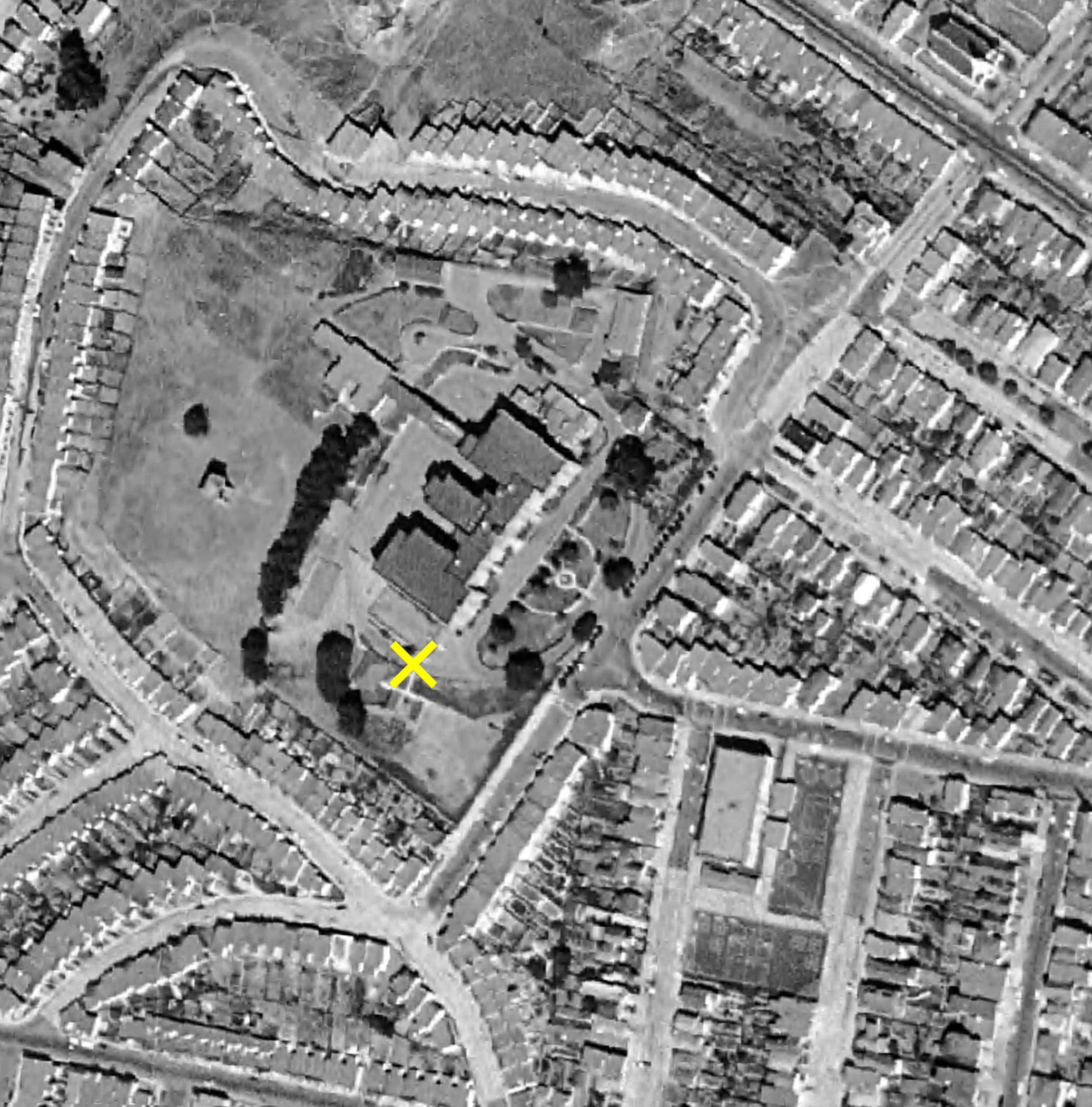
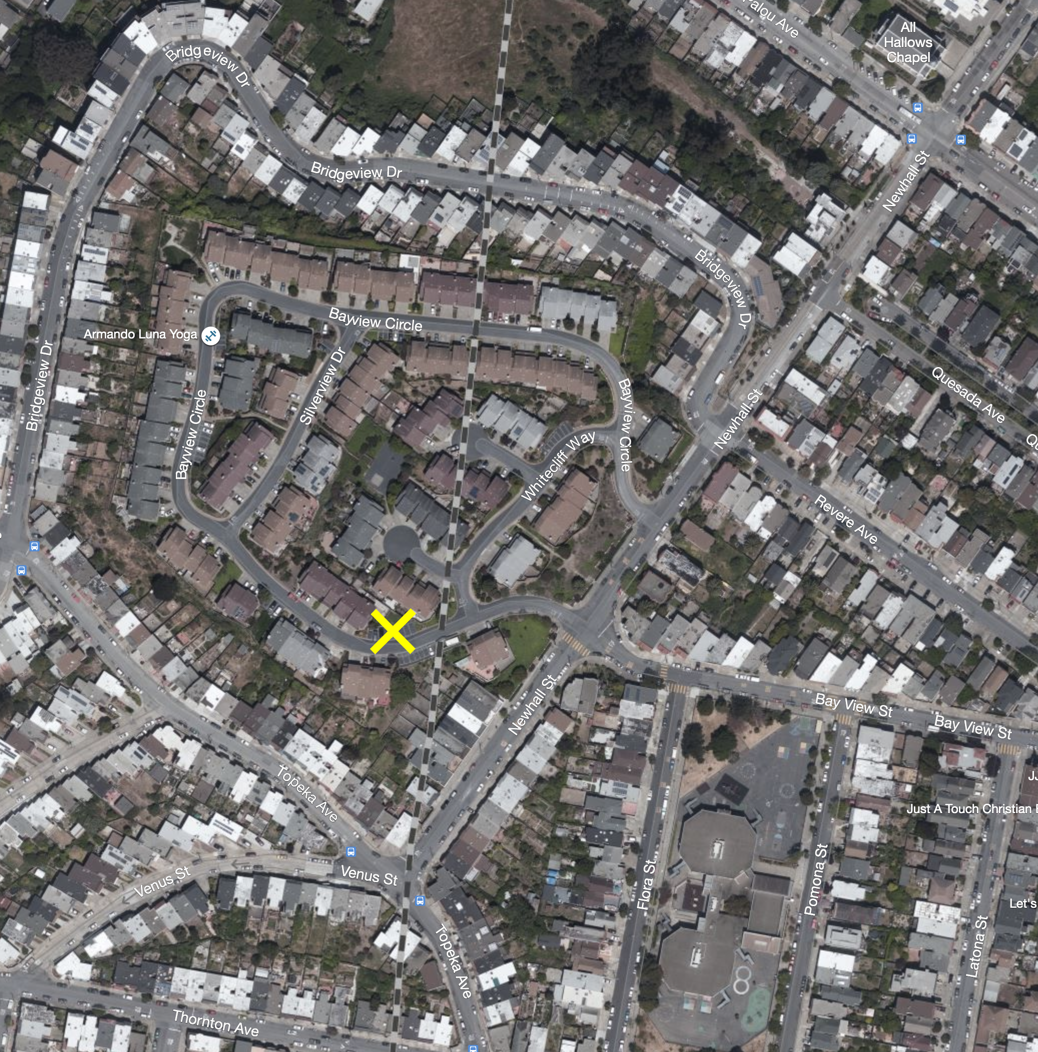
Then and Now… The precise location where the orphanage scene was filmed is marked by the ‘X’ on this recent satellite map (the dotted line indicates the path of the underground railway tunnel). Click or tap the image to see a matching 1956 aerial view, revealing Mount St. Joseph’s school and the playground, clearly seen below the ‘X’ .
Then … Joe seeks the advice of the Mother Superior who does little to assuage his grief.
… and Now, the same view today, capturing three neighborhoods. At left is the Caltrain railway line cutting through the Bayview. The center foreground is the Portola neighborhood and behind that, Visitacion Valley. San Bruno Mountain spans the horizon in the far distance.
… a vintage photo … here’s Mount St. Joseph’s School in 1929; the building would have looked the same to the moviemakers in 1956 when the location filming took place at the left side of the school. The Catholic Sisters of Charity built this structure in brick in 1911 after the wooden orphanage on the same site burned down. The Sisters closed the orphanage in 1977; it was bought by a developer who demolished it to make way for the Silverview Terrace subdivision whose 144 homes hit the market starting in 1984.
… and Now, in this same view from the junction of Newhall Street (crossing) and Bay View Street the Silverview Terrace houses beyond the palm tree sit on what used to be the landscaped area seen above in front of the orphanage school.
Then … The FBI agents follow communist sympathizer Radchek to a house in the Hayes Valley/Lower Haight district where he has rented a room in a Victorian Italianate building with three identical side-by-side units - 151, 153 and 155 Octavia Street bordering Rose Street (map).
and Now, that building has been torn down, replaced as has so often happened with a contemporary structure, 200 Rose Street, contributing no architectural interest whatsoever. Because of its ground floor garages this is one of the thousands of so-called ‘soft’ structures in San Francisco that are vulnerable to the next big earthquake unlike the extant solidly magnificent Victorians still standing across Rose Street.
Radchek climbs the middle set of stairs. Later he tells a contact that he is staying at “153 Octavia Street, 2nd floor front” which is the correct and precise address; unusual for a film script not to use a fictitious address, even back then.
Then … Ahead, Page street crosses in this view down Octavia from the newel post of the staircase above and that’s the Page Street Market on the corner at 198 Page.
Later … this 1991 view across Page and down Octavia shows dramatic changes. By 1959 the double-decker Central Freeway had been built after widening Octavia by razing several blocks of houses on its east side. The Page Street Market would have been under the freeway at the right edge of this photo.
and Now, another dramatic change! The freeway, damaged in the 1989 earthquake, was closed in 1996 and torn down in the early 2000’s, transforming Octavia into a wide, tree-lined road free of concrete blight.
O’Hara wiretaps Radchek’s phone and hears him speak to a contact - ‘Igor’. Not much to go on, but a definite lead.
Shortly afterwards they find, apparently deemed expendable by his contacts, Radchek’s murdered body in his room. The search for the FBI agent’s killer goes on.
The movie opens with a murder scene in a dark alley, most likely filmed on a Universal Studios back lot. A catholic priest, Father Tomasino, is walking along a dark lane; he hears his name called then is collared from behind and summarily dispatched with a knife.
Then … While the opening credits roll a responding police car is shown driving through different parts of the city. The scenes begin with a camera shot panning down from a church spire.
… and Now, this is All-Hallows Chapel at 1440 Newhall Street in San Francisco’s Bayview neighborhood looking just as the movie showed it over 60 years ago (map).
Then … the camera pans down to the street.
and Now, this view looks north along Newhall Street from Palou Avenue. The large structures that dominate in the distance are the Port of San Francisco’s Pier 92 grain silos, erected in 1918 alongside Islais Creek but ceasing operations after the 1989 earthquake.
As an interesting aside, the tall circulation tower attached to the silos was beautified in 2014 by the Port by way of a public arts project representing the neighborhood’s economy, ecology, and community. The eye-catching installation, prominently visible to all entering and leaving the city on the nearby elevated 280 freeway, continues to be a colorful gateway to the struggling Bayview neighborhood.
Then … the credits continue, now with a view of the Bay Bridge, making it clear the story is set in San Francisco.
and Now, this view looks east across Fremont along Harrison Street (map). The rapid modernization of this SOMA/Rincon Hill area has yet to swallow up the building at left on the Fremont corner. Note the large billboard still in the same spot today.
Then … In this shot we see, on the right, the sign of the upscale Blue Fox Cafe, one of the city’s most famous restaurants spanning a 51 year period from 1942 to 1993. Many celebrities dined there including Joe DiMaggio and Marilyn Monroe. Joan Crawford kept her own case of vodka there (perhaps inspired by Alfred Hitchcock who kept a private stash of wine at Ernie’s Restaurant, or was it the other way around?).
and Now, this is Merchant Street between Montgomery and Kearny at Portsmouth Square (map), where a Hilton hotel has long since replaced the old Hall of Justice that was on the left side, above. There is no longer a view down to the Bay from here unlike in the movie image: it’s blocked by the Transamerica Pyramid at Kearny and if that wasn’t there, by the Embarcadero Center farther down. The Blue Fox was at 359 Merchant; Alfred’s Steak House is the current occupant.
Citysleuth found this image in a 1956 travelogue. It’s the same sign as the one seen in the Then image above, positioned at the same spot where the vertical Alfred’s sign is now.