Then ... In the previous post Harold turned off Highway 1 in Pacifica towards the Mori Point trail head. Next we see him driving his Jaguar hearse on a trail around an S-bend.
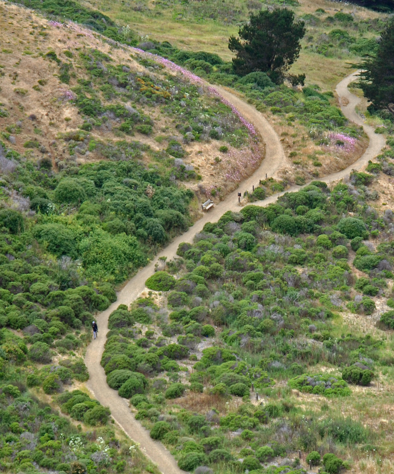
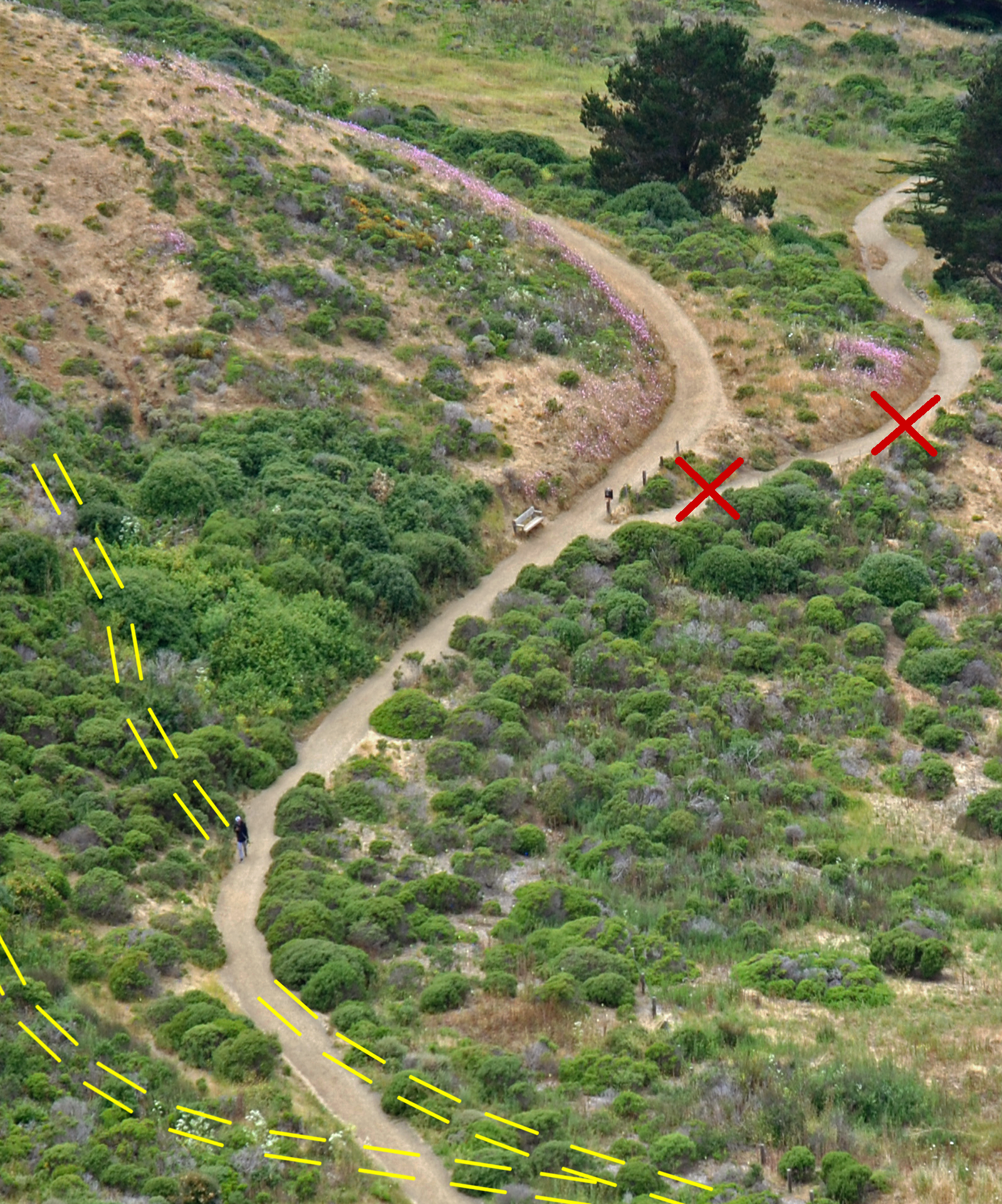
... and Now, Here's the same S-bend today. It's part of the Lishumsha trail that leads directly to Mori Point (map). It has seen some changes - the two trails joining from the left are gone, a new trail branches off at upper right and at the bottom the trail straightens out. Click or tap the image to highlight the changes since Harold's drive-by.
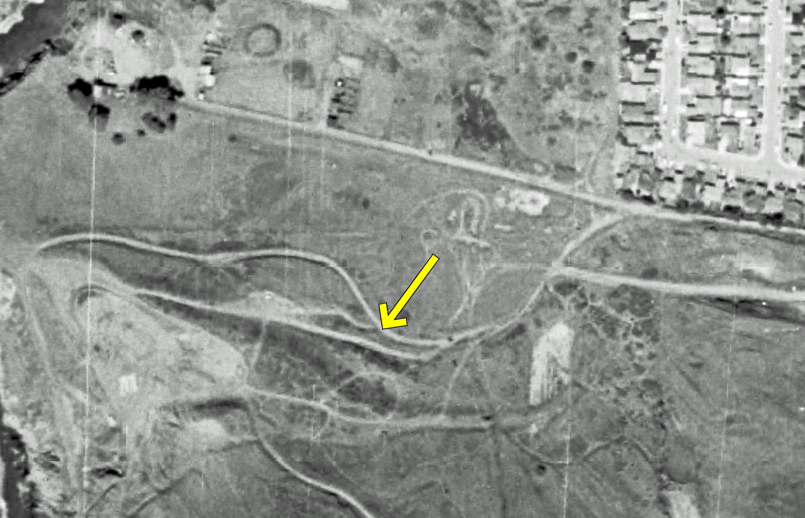
Citysleuth verified this location by overlaying a 1980 aerial image with a recent one (the arrow points to the spot where Harold's Jaguar hearse was in the Then image above). Click or tap it to see the changes.
Looking back from the S-bend, CitySleuth has indicated the hilltop where the camera that filmed it was set up.
Harold And Maude location fanatics can find their way to the S-bend from Highway 1 (on the right) using this trail map.
Then ... The trail continues on to the top of Mori Point. As Harold drives up we see Pacifica spread out along the coast with Mount Tamalpais and the hills of Marin County in the distance at left.
... and Now, in today's view there's a feature not there in the movie - the Pacifica pier, constructed two years later in 1973. It carried a sewer pipe a quarter mile out from the shore to dump its miasmic effluent until a wastewater treatment plant came online years later.
Then ... There's a collective gasp from the audience as the Jaguar plunges over the cliff edge near Mori Point - it glints in the sunlight just below the cliff top (click the image for a closer look).
... and Now, CitySleuth risked life and limb scrambling to a spot near the cliff edge that afforded a similar view. All in a day's work.
The car lands wheels up with a sickening thud. Say it ain't so! Can the movie really end on such a shocking note?
Then ... Pheww! The camera slowly pans up and we see Harold standing at the cliff edge looking down to the crashed vehicle. Somehow he got out in time, wickedly feigning his suicide just as he did several times earlier in the movie.
... and Now, there's been erosion over the years but the cliff face is still very recognizable. The lady who happened to be walking her dog when CitySleuth took this matching shot had no idea she was standing so close to where Harold had been.
Then ... The movie ends as Harold picks out 'If You Want To Sing Out, Sing Out' on his banjo strings while doing a little jig. This upbeat ending, suggesting he will get over his loss, won out in a scriptwriting debate over an alternative ending that would have kept Harold in the crashing car.
... and Now, this view today is for the most part just the same.
Then ... Val continues on her desperate dash to the Butchertown Bridge. The company sign in the background gives us a clue as to this location, supposedly in San Francisco but, as it turns out, filmed in Los Angeles ...
Here's an old ad for the California Corrugated Culvert Co. Of its two addresses, the shot above is the Los Angeles location east of Chinatown, looking towards Leroy Street from the railway tracks alongside the Los Angeles River (map).
... and Now, in 1942 the William Mead Homes public housing project was built on the 15 acres alongside Leroy Street , still there today.
The cops are next seen pursuing Val at a location yet to be found ... possibly the industrial area south of Market in San Francisco.
Then ... Val arrives at the bridge where a man is waiting for her. A train track on the right parallels the roadway over the bridge.
... and Now, believe it or not, this is the same view today. But where is it and why does it look so different? Read on ...
Here's the bridge in a 1930 photograph. Built in 1924 as the Badger Avenue Bridge, it linked San Pedro with Terminal Island across the Cerritos Channel (map). When a Ford assembly plant was built in 1930 on the island (seen below in the background), the bridge became known as the Henry Ford Bridge. The bridge design is known as a Bascule bridge - this one is unusual in that it is a combination of two back-to-back Bascules, each with three massive counterweights. The movie image above was shot from the far left on the south (Terminal Island) side.
Then ... When Tony's cab reaches the bridge as a train reverses by we get a closer look at the bridge's triple counterweights.
... and Now, an aerial view of the bridge today (with Terminal Island on the right) shows many changes. The original road/rail bridge has been replaced by two bridges: the Commodore Schuyler Heim road bridge since 1948 and a vertical lift railway bridge that replaced the Bascule bridge in 1996 (the nearest one). (The Now image above was taken from the spot arrowed at right).
So the bridge scene was filmed in Southern California even though San Francisco has a Bascule bridge of its own, the Lefty O'Doul Bridge crossing Mission Creek (McCovey Cove) at 3rd Street in China Basin (map). It's next to the SF Giants' ballpark and just blocks north of the old Butchertown neighborhood. Unlike the Henry Ford Bridge this one is a single bridge and has only two counterweights, but it's still in use today. Built in 1933 it was there when the movie was filmed so why the moviemakers didn't film here is anyone's guess.
Blizzard has another diabolical plan - he now turns his attention to Ferris, the doctor who had needlessly amputated his legs. He begins by kidnapping Ferris's assistant and taking him to the fully equipped operating room that he had set up in his cellar for this very moment.
Then ... He then calls Ferris telling him his daughter Barbara is at his house, injured. He wastes no time rushing over.
and Now... this is 59 Wentworth Place in Chinatown, described in more detail in an earlier post. Note that the sidewalk has since been widened and the lampposts shifted outwards.
Rose is mortified when she overhears Blizzard demanding that Ferris remove the legs from his assistant and graft them onto him otherwise harm will befall the doctor's daughter. Despite her love for Blizzard, she is shocked into action, rushing off to get help from her Secret Service colleagues...
... but they arrive to find that, instead, Ferris had finally treated the original injury, a contusion on the brain that had all along been the cause of Blizzard's bizzare and criminal behavior. Rose is overjoyed to see that he is now not only mentally cured but determined to right his wrongs.
Unfortunately, a happy ending is about to be thwarted by Blizzard's cronies who, hearing of his transformation to righteousness, are fearful he will shop them...
Blizzard's new life - he and Rose are now married, is short-lived when Frisco Pete shows up and dispatches him with a single shot.
Maude's death has left Harold bereft and confused. He takes off on a long drive in his Jaguar prompting our concern for his well-being. Director Hal Ashby chose to include the drive as a series of clips interspersed within the hospital scenes but CitySleuth presents them here sequentially in the order in which they appear in the movie. They were filmed south of San Francisco, jumping from place to place across the peninsula without regard to geographical continuity.
Our first view of the drive is here, somewhere in the hills on a wet and gloomy day. CitySleuth is still searching for the location.
Then ... He's next on a curving coastal highway passing a golf course on the left between the road and the ocean.
... and Now, this view looks north from an overpass crossing Highway 1 in Pacifica (map). The Sharp Park neighborhood of Pacifica is straight ahead and the seaside links course, now shrouded from here by tall trees, is the Sharp Park Golf Course. A central concrete divider has since been installed to make the highway curve a little safer.
Then ... Back in the hills ...
... and Now, ... this is miles away on Pescadero Creek Road, halfway between the little town of Pescadero and the Pacific Coast (map). Location nuts visiting this spot should take the opportunity to stop for lunch at the popular Duarte's Tavern in Pescadero, a way station serving hungry travelers since 1894.
Then ... The rainy weather is beginning to clear up.
... and Now, This S-curve looks awfully like the same location, also on Pescadero Creek Road but deep in the hills between Alpine Road and Loma Mar (map). At this and the previous Pescadero Creek Road location the white center line has been upgraded to yellow reflectors.
Then ... Next he's driving alongside a cemetery that he and Maude had visited earlier in the movie.
... and Now, it's the Sneath Lane side of the Golden Gate National Cemetery in San Bruno (map).
Then ... Back at the coast, returning to Pescadero, the Jaguar turns from Pescadero Creek Road onto Highway 1 and heads north (map).
... and Now, Then and Now comparisons of rural locations often show little change over time.
Then ... He is still on Highway 1 but now 29 miles further north in Pacifica. Where is he going? What will he do? (Patience, dear readers, the next blog post will reveal all).
... and Now, this is the Mori Point Road junction. The turn-off takes hikers to the Mori Point trail a short distance away (map).