Back at the office Callahan is less than enthusiastic when Chico Gonzalez (Reni Santoni), a college graduate, is assigned to replace his recently injured partner.
Then … The next scene unfolds at a park adjacent to a Catholic church.
… and Now, This is the park at Washington Square in North Beach (map); the church is the twin-spired Saints Peter and Paul Church at 666 Filbert Street. The statue of Benjamin Franklin, seen above in the center of the park, is still there now but surrounded by trees (partially visible below, right of center). The park is a popular hang-out for residents, the crowd below showing a disdain for masks in the early months of the pandemic, an attitude that fortunately changed later on.
Then … The camera then pans to the Dante Building, on the right at 1606 Stockton Street, an office/retail building on the corner of Union Street.
… and Now, trees line the perimeter of the park but the building remains the same, as does the home of the San Francisco Italian Athletic club next to it on the left (where, incidentally, CitySleuth has taken evening classes in Italian). To its left is the local U.S. Post Office and Coit Tower; the sentinel of Telegraph Hill is in the upper left corner.
Then … The Scorpio killer is on the roof of the Dante Building, disgusted at the city’s delaying tactic in coming up with the ransom and determined to carry out his ‘one-a-day’ threat. The Nob Hill skyline includes the Brocklebank at far left - home to Madeleine in Hitchcock’s classic Vertigo.
… and Now, 50 years on the skyline is surprisingly the same but the rooftop only partially so. The gravel roof has been resurfaced and the ductwork is mostly but not all gone. The flagpole survived!
Then … He scans the park for a potential victim.
… and Now, here’s the same view today. The first Saints Peter and Paul church stood a block and a half away on the corner of Filbert and Grant from 1884 until 1906 when it was destroyed by the earthquake and fire. The extant church is approaching its centennial - it was built in 1924.
This recent aerial view shows the Dante Building relative to the park and church.
Then … From a police helicopter passing over North Beach a couple of blocks from the park the policemen spot Scorpio on the Dante building rooftop, just out of this view on the left.
… and Now, this is the junction of Union Street (crossing right to left) and Kearny, seen below in a recent Google satellite view.
Scorpio notices a gay couple crossing the park. When they sit on a park bench he gleefully takes aim but is startled by the police above him and he dashes off, giving them the slip but sparing the target.
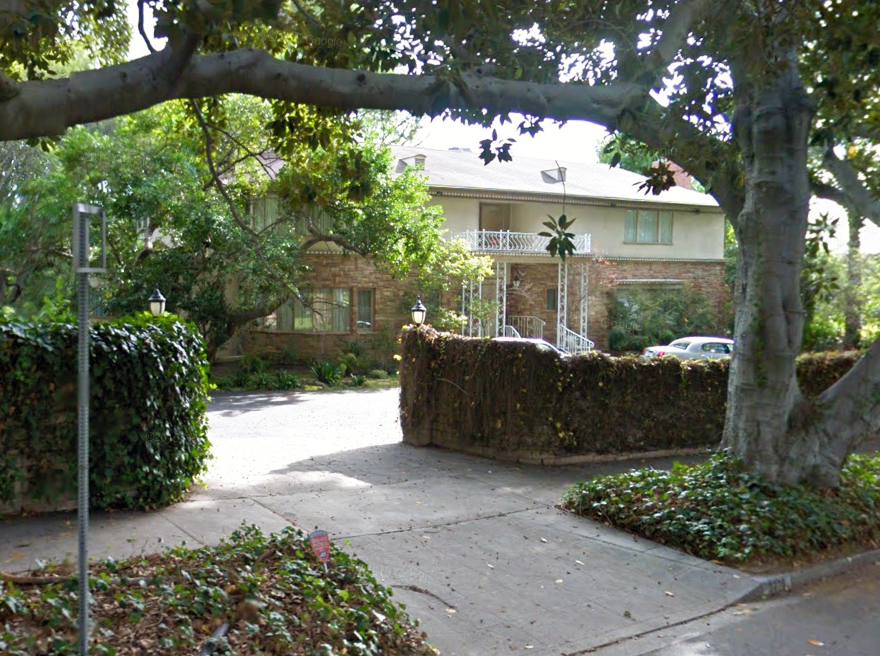
Ed responds to Lois’s plea for help, driving over to her home - it’s seen several times throughout the movie. The address in the movie is 2370 Del Mar and indeed the front entrance is so numbered.
Then … Ed pulls into the driveway, giving us a wider view of the home’s exterior including an interesting old-style street lamp. There’s an upstairs balcony over the entrance supported by decorative metal posts, seen up close above.
… and Now, the house has hardly changed in over 70 years. Even the street lamp is still there. But it’s not in San Francisco - this is 2370 N. Vermont Avenue in Los Feliz, a hillside neighborhood in the greater Hollywood area of Los Angeles (map). Last sold in 1973 for $80,000, the home is currently valued at over $4 Million.
Then … In another scene we see the entrance from a different angle, revealing more of the house.
… and Now, from here we can see one small change: a pair of railings, matching the original posts in style, have since been added on the steps.
Lois lets him in. She’s in a tizzy as she pours out some startling news. The expansive interiors of the Frazer home were most likely filmed on a sound stage at the General Service Studio in Hollywood (in which case they did a nice job here matching the front door with its sidelites; compare it from the outside in the first image above).
Fresh crabs in hand, Perry Mason heads to Luigi’s Italian Restaurant where Luigi allows him to personally cook them for his friends. There was no such eatery in San Francisco in 1935 - this was filmed at Warner Brothers Studios.
But he takes a break when an old flame, Rhoda (Margaret Lindsay), stops by. She tells him about the husband of a friend of hers who reportedly had died four years earlier but may have recently been seen alive. She wants to remarry but needs to ascertain the husband’s legal status. Mason isn’t fooled - he realizes the ‘curious bride’ is Rhoda herself.
When Rhoda leaves she forgets to take her purse and a surreptitious peek confirms Mason’s suspicion - a telegram inside suggests she is being blackmailed. He also sees a small handgun. For protection? Or… no no, surely she wouldn’t…
Rhoda walks to her car followed by, as it turns out, her new husband Carl Montaine (Donald Woods). He too is curious, he wants to find out why she has been acting strangely. Once again this location cries out “Back Lot”, filmed at Warner Brothers Studios.
She pulls into the driveway of her home but there is little in the way of clues here to identify it.
Then … Fortunately later in the movie Mason drives here during daytime which reveals its location. As he approaches her home this block, with a single set of cable car tracks, is familiar to CitySleuth.
… and Now, we are looking east down Washington Street with Lafayette Park on the right. The tall swanky apartment building is 2006 Washington and at far left at 2080 Washington, mostly hidden behind a monster privacy hedge, is the Adolph Spreckels Mansion, now the home of author Danielle Steel. (CitySleuth recognized the block having posted about it in Pal Joey and The Man Who Cheated Himself). The tracks of the east-bound Washington Street section of the Washington-Jackson cable car line were removed after the line was shut down in September 1956.
Then … Mason pulls up in front of Rhoda’s home. In the script it was 2309 Hawthorne Avenue but in real life this is 2100 Washington Street on the corner of Octavia (map).
… and Now, comparing the home (as best we can through those darn trees) to the nighttime view above, some of the architectural detailing on the lower level has been eliminated - more’s the pity. The Spreckels Mansion is partly visible at far right.
Then … After parting ways with Jane at the Southern Pacific depot George isn’t ready to give up on her. He pulls into a Union 76 gas station to ask for directions to San Luis Obispo.
… and Now, this gas station was located opposite Grace Cathedral on the corner of California and Jones (map); it was replaced in 1972 by the Gramercy Towers condominiums. Along California where Mason Street crosses you can see the brownstone Pacific Union Club where Scottie Ferguson met with the scheming Gavin Elster in Hitchcock’s classic Vertigo. Incidentally, a scene in Bullitt filmed at the cathedral included views of the club and the gas station.
Then … Armed with the vaguest of directions …”You have to go ‘round the other way”, he heads south, a good start given that San Luis Opispo is 230 miles south of San Francisco.
… and Now, in this recent shot of Jones viewed from California most buildings are unchanged except for Gramercy Towers occupying most of the block on the left.
Then … We next see a series of overheads of George racing south intent on arriving before the train does. As is often the case in movies the locations are anything but sequential. In this aerial a Southern Pacific train passes under a freeway overpass whose center lanes were still under construction (in 1969).
… and Now, CitySleuth is grateful for reader Notcom (see his comments below) for identifying the various locations of the aerial shots of the train seen in this post. This one is where Highway 101 crosses the Caltrain line at Sierra Point near Brisbane (map). Note the walls beneath the overpass that create a protected corridor for the passing trains, visible in both Then and Now images. The construction work above expanded the overpass from six to eight lanes. This line does indeed lead to San Luis Obispo except the train above happens to be heading north to San Francisco.
Next we see George’s ‘Vette following the railroad tracks past a series of orchards, part of California’s agricultural industry made up of thousands of such small farms. Most of the Bay Area’s orchards have long since been gobbled up by housing for the growing population.
Then … This aerial (a different train!) captures an expressway overpass in a suburban town.
… and Now, this is the CalTrain line passing under the Woodside Road (Highway 84) overpass near Middlefield Road in Redwood City, 25 miles south of San Francisco (map). Once again the train above is heading north to San Francisco.
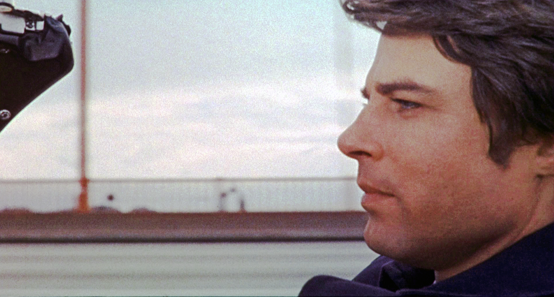
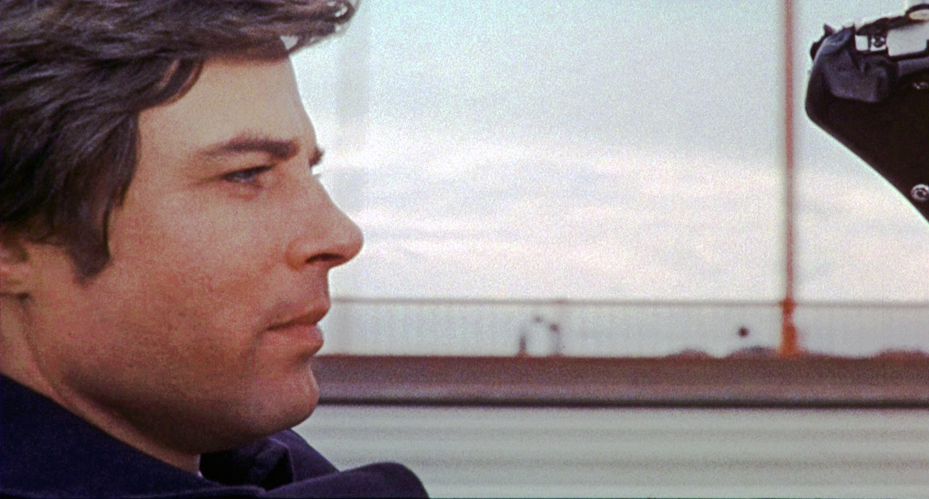
Then … Now George is crossing a bridge … but where is this? The answer is revealed by the distant rock formation seen through the railing: the rocks at Point Bonita (map), so he’s on the Golden Gate Bridge, way north of his intended route. But kudos if you noticed something odd here, because, given that Point Bonita is to the west of the bridge he appears to be driving in the wrong direction. Click or tap the image to revert him to the real world.
The film editor had flipped this footage to fool the audience because he had used it in an earlier scene in the movie - see below. At this spot on the bridge the rocks, and a part of the Marin Headlands, are clearly seen. Reusing this clip though was a continuity goof because he’s wearing a dark overcoat whereas he had on a plaid overcoat when he started his trip (and as we will see, when he arrives at his destination).
… and Now, here’s the same view today from the slightly higher vantage point of the Google Street View’s roof-mounted camera. Today’s image also shows the moveable center barrier in the foreground that was installed in 2015; another addition is the pedestrian walkway railing for protection from passing cars that blends in seamlessly with the bridge’s design.
… and Now, this beautiful view of the bridge looks back from above Point Bonita. The Marin Headlands are on the left; the city spreads out on the right like Xanadu-on-the-bay. The lighthouse at the tip of the point is a popular hiking destination.
Then … Now he has caught up with the train, the same as the one first seen 6 images above.
… and Now, we are now in Burlingame, 16 miles south of San Francisco. The T-junction at top left is Toyon Drive and Carolan Avenue (map). But, oops, George needs once again to be told that this train is heading north, not south.
Then … What the …? He’s back in San Francisco driving along Auto Row past the Reynolds-Seiler Toyota dealer at 1465 Van Ness Avenue on the southwest corner of Pine Street; he then passes a Standard gas station across Pine (map). But in a repeat of the earlier continuity goof he is again wearing the dark overcoat.
… and Now, that block where the dealer was fell prey to the San Francisco Towers, a 250 unit senior living community complex and street level retail stores. The construction mess on Van Ness is the result of an ongoing upgrade of the thoroughfare to add dedicated bus lanes - observing its multi-year progress is, to residents, like watching grass grow. But the gas station is still there across Pine Street, and (interesting trivia) it’s a unique one - it’s the sole remaining Standard station in California. Intrigued? Read about it here.
He continues following that same train. The Johnson’s Wax building is a clue to this location.
Then … Next we see him on a bridge over a large body of water.
… and Now, Back in the Bay Area, again way north of his supposed route, he was traveling east to west on the steep rise to the elevated section of the San Mateo Bridge that spans San Francisco Bay from Foster City to Hayward (map). The arrow marks where he was in the above shot.
And finally he arrives at his destination, San Luis Obispo’s Southern Pacific depot. Or is it? And does he beat the train? Don’t miss the next post for the answers!